Lynne Raughley
Posts tagged with Maps
Showing 1 - 2 of 2 items
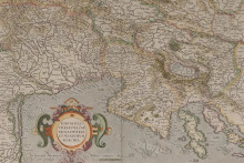
A recent gift to the library brought a collection of remarkable maps, along with the remarkable story of the man who collected them.
Back in 1964, Dr. Stevo Julius (1929-2025) left his home in Zagreb, Yugoslavia, emigrating to the United States to take up a position in the University of Michigan health system. Upon his death 60 years later, he left behind a substantial legacy. Among the highlights: research breakthroughs on hypertension and metabolic syndrome that helped establish the university as a global leader in cardiovascular research; a research professorship in his name to honor these achievements; a thriving family and a scientific community nurtured over many decades by Julius and his wife, Susan; and a personal history of fighting fascism in his youth as a Jewish member of the Partisan movement during World War II.
Back in 1964, Dr. Stevo Julius (1929-2025) left his home in Zagreb, Yugoslavia, emigrating to the United States to take up a position in the University of Michigan health system. Upon his death 60 years later, he left behind a substantial legacy. Among the highlights: research breakthroughs on hypertension and metabolic syndrome that helped establish the university as a global leader in cardiovascular research; a research professorship in his name to honor these achievements; a thriving family and a scientific community nurtured over many decades by Julius and his wife, Susan; and a personal history of fighting fascism in his youth as a Jewish member of the Partisan movement during World War II.
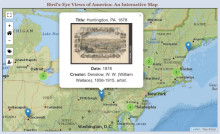
This project's intent was to catalog, digitize, and present a selection of bird's-eye prints of American cities held by the Clements Library. The library started collecting bird's-eye views in earnest during the tenure of current director, J. Kevin Graffagnino. Looking for an innovative and unique way to display these views, Corey Schmidt, under the supervision of the Curator of Graphics Material, Clayton Lewis, began working to build an interactive display for these views. Schmidt worked with a mapping system called Leaflet. Leaflet is an open-source, interactive display (JavaScript library) for maps and geographic data. Because the Image Bank already contained the metadata for each view, Schmidt wrote a program that searched through the Image Bank API and retrieved this data, which was then used with Leaflet's map display to create the map found on their online exhibit.