Corey Schmidt
Posts tagged with Leaflet in Blog The Digital Collections Files
Showing 1 - 1 of 1 items
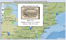
This project's intent was to catalog, digitize, and present a selection of bird's-eye prints of American cities held by the Clements Library. The library started collecting bird's-eye views in earnest during the tenure of current director, J. Kevin Graffagnino. Looking for an innovative and unique way to display these views, Corey Schmidt, under the supervision of the Curator of Graphics Material, Clayton Lewis, began working to build an interactive display for these views. Schmidt worked with a mapping system called Leaflet. Leaflet is an open-source, interactive display (JavaScript library) for maps and geographic data. Because the Image Bank already contained the metadata for each view, Schmidt wrote a program that searched through the Image Bank API and retrieved this data, which was then used with Leaflet's map display to create the map found on their online exhibit.